

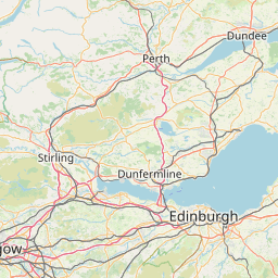
Peffer Burn; Athelstaneford; EAST LOTHIAN; SCOTLAND
Subscription required for access to zoomable images


Frame details
Date: 27 August 1943
Location: Peffer Burn; Athelstaneford; EAST LOTHIAN; SCOTLAND
Coordinates (lat, lon): 55.992860, -2.707550
Description: East Fortune airfield-Marksman farm
Location: Peffer Burn; Athelstaneford; EAST LOTHIAN; SCOTLAND
Coordinates (lat, lon): 55.992860, -2.707550
Description: East Fortune airfield-Marksman farm
Image type: Vertical
Scale: 6600
Scale: 6600