

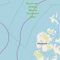
Ward; The (Burnt Mound); St Andrews and Deerness; ORKNEY; SCOTLAND
Subscription required for access to zoomable images


Frame details
Date: 04 July 1942
Location: Ward; The (Burnt Mound); St Andrews and Deerness; ORKNEY; SCOTLAND
Coordinates (lat, lon): 58.959700, -2.759770
Description: Mirkady Point-Deerness Radar station-The Bought
Location: Ward; The (Burnt Mound); St Andrews and Deerness; ORKNEY; SCOTLAND
Coordinates (lat, lon): 58.959700, -2.759770
Description: Mirkady Point-Deerness Radar station-The Bought
Image type: Vertical
Scale: 8000
Scale: 8000