

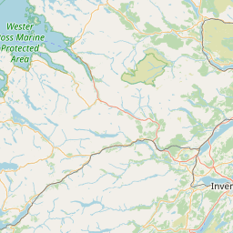
Moy Burn/Allt à Mhaigh; Laggan; INVERNESS-SHIRE; SCOTLAND
Subscription required for access to zoomable images


Frame details
Date: 10 June 1988
Location: Moy Burn/Allt à Mhaigh; Laggan; INVERNESS-SHIRE; SCOTLAND
Coordinates (lat, lon): 56.917053, -4.466887
Description: Part of the All Scotland Survey.
Location: Moy Burn/Allt à Mhaigh; Laggan; INVERNESS-SHIRE; SCOTLAND
Coordinates (lat, lon): 56.917053, -4.466887
Description: Part of the All Scotland Survey.
Image type: Vertical
Scale: 24000
Scale: 24000