

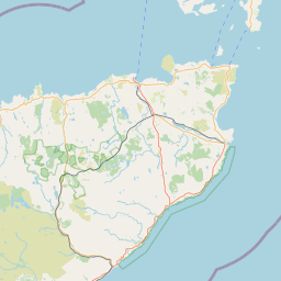
Lower Riess; Wick; CAITHNESS; SCOTLAND
Subscription required for access to zoomable images


Frame details
Date: 07 May 1988
Location: Lower Riess; Wick; CAITHNESS; SCOTLAND
Coordinates (lat, lon): 58.480547, -3.145052
Description: Part of the All Scotland Survey.
Location: Lower Riess; Wick; CAITHNESS; SCOTLAND
Coordinates (lat, lon): 58.480547, -3.145052
Description: Part of the All Scotland Survey.
Image type: Vertical
Scale: 24000
Scale: 24000